PRODUCT
DSμRAD
(Direct RF Sampling Hyperspectral Microwave Radiometer)
- TOP >
- PRODUCT | Hyperspectral Microwave Radiometer DSμRAD
Instantaneous brightness temperature spectrum measurement of vertically and horizontally polarized microwave from 512 MHz to 41.472 GHz at 13.5 MHz spacing.
This product was jointly developed with JAXA (Japan Aerospace Exploration Agency).


How is DSμRAD different from other devices?
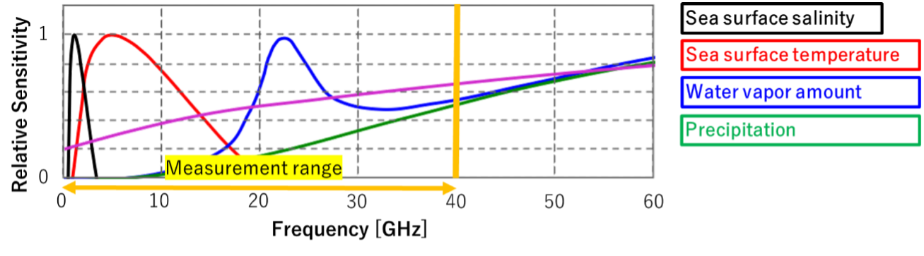
The biggest difference is that by widening the bandwidth, there is a frequency suitable for the geophysical parameter to be observed, and various geophysical parameters can be measured with a single unit.
How is DSμRAD different from other devices?
Brightness temperature observed with a microwave radiometer represents the intensity of microwave radiation emitted by a source, expressed in temperature units (Kelvin). It reflects the physical temperature and emissivity of the observed surface or atmosphere. In Earth’s atmosphere, it is used to analyze water vapor, cloud liquid water, and precipitation, as well as surface properties like sea ice and soil moisture. This parameter is crucial for meteorology, climate studies, and remote sensing applications.
Why is it good?
The first point is that widening the bandwidth creates a frequency suitable for the geophysical parameters to be observed, allowing various geophysical parameters to be measured with a single unit.
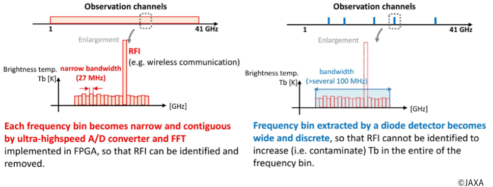
The second point is high frequency resolution.
This advantage is to identify and separate natural-origin microwave signals from observed signals contaminated with artificial microwave signals.
Overview
For example, by measuring ultra-wideband microwave power in the environment, the amount of water vapor in the atmosphere can be retrieved.
The ultra-wideband AD conversion technology and digital spectral processing cultivated by Direct RF Samplers with DSP can measure ultra-wideband microwave spectrum in high frequency resolution instantly.
ELECS Industry is the first in the world to realize this concept▲1 as the hyperspectral microwave radiometer DSμRAD▲2.
▲1 Patented
▲2 Based on our research
Applications
Passive microwave remote sensing (geophysical parameters retrieval) and monitoring electromagnetic environments in microwave band
Features
- Instantaneous brightness temperature spectrum measurement of vertically and/or horizontally polarized microwave from 512 MHz to 41.472 GHz at 13.5 MHz spacing.
- Miniaturization with ultra-wideband direct RF sampling (under-sampling) technology.
- Calibration to the brightness temperature spectrum using only passive elements, not liquid nitrogen or noise diodes▲3.
▲3 Patented
Specifications
| Observation polarization | Vertical and/or Horizontal
* Decide the number of observation polarizations when ordering. |
|---|---|
| Channel spacing | Selectable from 13.5/27/54/108/216/432 MHz for every installed frequency module at the start of measurement. |
| Integration time | Selectable from 1/10/100/1000 msec for every installed frequency module at the start of measurement. |
| Brightness temperature measurement range | 3 ~ 1200 K |
| Brightness temperature measurement precision | Typ. 1 K (@300 K) |
| Power supply | AC 100-240 V or DC 12-36 V |
| Dimensions | 700 x 270 x 270 mm *Excluding protrusions such as rubber feet and handles |
| Weight | Max 30 kg *Depends on the number of observation frequency modules and observation polarizations |
Cost-Performance
Conventional microwave radiometers have low-resolution and intermittent frequency measurement capabilities, with only about 2–10 frequency channels.
Our product features up to approximately 3,000 frequency measurement channels, offering overwhelmingly lower costs per channel.
Benefits of Application
With its broad frequency range of up to 40 GHz and its ability to precisely detect intermittent and time-varying signals, this device’s advanced digital spectroscopy method makes it highly suitable for security-related fields such as detecting suspicious vessels, border surveillance, and monitoring illegal radio waves.
Additional Features
This device is a passive receiver that does not transmit microwaves. Unlike visible light- or infrared-based observation devices, it is capable of measurements even at night or under cloudy conditions—an advantage particularly relevant in Japan’s climate.
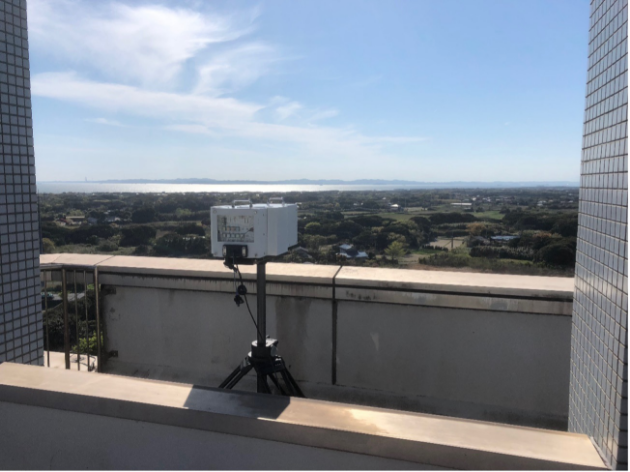
Observation scenery
Monitoring of the electromagnetic environment in Tokyo Bay using DSμRAD.
Media coverage
The demonstration experiment conducted in Ishikari, Hokkaido was reported on TV and in newspapers. (The Nikkei, The Mainichi, The Yomiuri Shimbun, NHK, HBC, etc.)
Summary
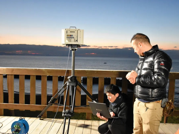
The Japan Aerospace Exploration Agency (JAXA) and Elecs Industry Co., Ltd., an electronics development company based in Kawasaki City, conducted a demonstration experiment in Ishikari City, Hokkaido, to detect poaching vessels by capturing signals from shipborne radar. The experiment utilized JAXA’s measurement technology capable of simultaneously observing a wide range of radio frequencies. Observational data will be validated by the end of this fiscal year, aiming for practical application by fiscal year 2026.
From November 18 to 21, a vessel simulating a poaching boat was positioned approximately 500 meters offshore. Onshore, a measurement device developed by Elecs Industry Co., Ltd. based on JAXA’s technology was installed. The device detects microwaves, a type of electromagnetic wave emitted by shipborne radar and satellite phones, enabling the identification of poaching vessels even at night when visual confirmation is difficult.
This demonstration is part of a subsidy project by Ishikari City, aimed at solving regional issues and fostering new industries in collaboration with emerging companies. The goal is to detect poaching vessels and prevent the illegal harvesting of sea cucumbers. Additionally, observational data will be stored in a local data center for analysis, paving the way for new applications of the facility.
Source
T. Maeda, N. Kawaguchi, K. Harada, K. Ozeki, Y. Chikahiro, H. Onuki, Y. Hayashi, K. Ema, K. Naoki, M. Nakayama, and T. Takano: Direct RF Sampling Hyperspectral Microwave Radiometer (DSμRAD) for Ground Use, IEEE Geoscience and Remote Sensing Letters, doi: 10.1109/LGRS.2020.2990707.